Increase Resolution of a Simulated Subsurface Property with Machine Learning in Seconds, not Hours.
Introduction
Subsurface forward modeling simulation methods, such as basin modeling, can be labor-intensive. Additionally, simulation times are high at a regional basin scale. Companies face the problem of increasing the resolution of the models and reducing the simulation time. The solution we consider is a combination of basin-modeling forward simulation with super-resolution machine-learning architecture to predict rock properties at basin scale with higher resolution, but considerably decreasing the time to simulate the properties compared to high-resolution basin modeling simulations. This solution does not inject any new information, such as geostatistical methods. However, it decreases simulation time by orders of magnitude without significantly compromising the quality of the resulting property maps.
Motivation and our approach
Subsurface geological forward modeling, including basin forward modeling technology, enables geological processes in the sedimentary basin to be evaluated over geological time (10s to 100s million years) , from the start of sediment deposition through the tectonic and stratigraphic events experienced by the sediments to their present-day state. It is an essential standalone and complementary approach to traditional porosity, heat, or pressure prediction methods for subsurface resource exploration and exploitation.
To keep up with the evolution of geological knowledge through a basin scale, these powerful simulation methods can be very labor-intensive and hamper the regular updating of the models with the most recent data and information . Additionally, simulation times are high at a regional scale. Simulating a large-scale basin model with moderate or high grid-cell resolution often takes many hours or days, depending on the available computational memory. Thus, companies face the problem of increasing the resolution of the models and reducing the simulation time while simultaneously reducing costs and increasing effectiveness.
The solid path in Figure 2 demonstrates the traditional approach in the Petromod™ basin modeling software package. Suppose a subsurface exploration team has a low-resolution 3D grid of the subsurface, but a higher resolution is required for further subsurface assessment. To increase a model resolution on the present-day moment (or any other period of geologic time), a subsurface modeler must run the entire simulation of the sedimentary basin evolution in space and time on a newly defined high-resolution grid; i.e., hundreds of millions of years of simulation of subsurface evolution! Alternatively, a modeler simulates a low-resolution grid, analyzes an output, and runs the entire simulation on a high-resolution grid. This widely accepted approach is physically governed but time inefficient, especially when the resolution increase during the simulation is not significant enough to change the geological pattern of the simulated property significantly.
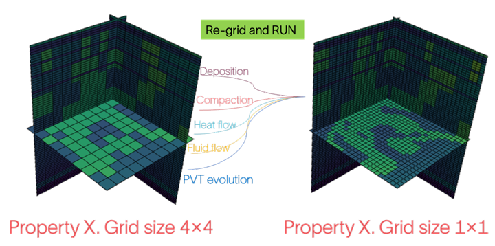
Figure 1. To increase property resolution, a user must re-run the entire basin simulation over ten-hundreds million years on a denser grid.
We developed an approach that uses a machine-learning super-resolution technique to increase the subsurface rock properties from low to high resolution, as shown in Figure 2. Our approach will significantly decrease simulation time without substantial quality compromise. This efficiency will help geoscientists and basin modelers make faster exploration and exploitation decisions.
As demonstrated in the dotted path in Figure 2, the super-resolution approach does not replace but complements subsurface forward modeling simulations. A user still needs to simulate low-resolution rock properties using a numerical solver. Still, unlike the traditional approach, to increase the resolution of the rock properties, the user can run a super-resolution machine-learning script on a low-resolution grid without resimulating the entire geological system evolution with a numerical solver on a high-resolution grid. It can be an option in the Petromod user menu, as in Figure 3.
A step-by-step machine learning approach for property resolution increase is below:
- Prepare a subsurface model for forward simulation. This includes but is not limited to, structural and facies maps and the initial properties of the rocks and fluids.
- Set up low-resolution simulation parameters and “Run super-resolution” for a property.
- Run the simulation.
- Save both low and high resolution of the simulated rock property
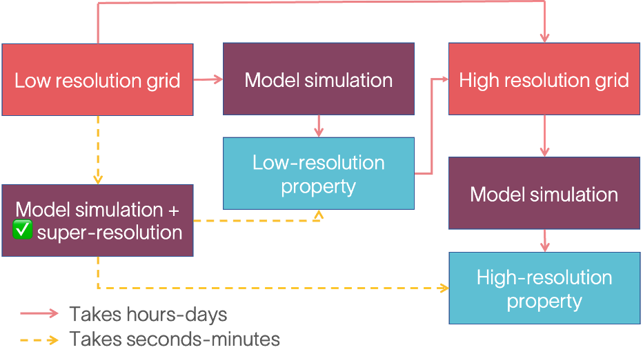
Figure 2. Solid line - traditional approach in subsurface forward modeling; dotted line - super-resolution approach in subsurface forward modeling.
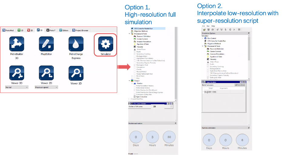
Figure 3. Simulation options to increase property resolution. Option 1 is the traditional approach in Petromod, and Option 2 is the super-resolution approach in Petromod.
Machine learning model
To approximate static properties on a high-resolution grid at speed and scale, we use the concept of machine-learning image super-resolution and apply it to 3D simulated static property grids of basin models. Super-resolution of images refers to augmenting and increasing the resolution of an image using classic and advanced super-resolution techniques. We use the same approach but for subsurface rock properties, where each array value is not a pixel intensity but porosity, stress, pressure, or other subsurface properties.
There are many machine-learning super-resolution model architectures available in the public domain. Most are based on the specific type of deep-learning neural networks applied for computer vision—convolution neural networks (CNN), transformers, or their combination. We use custom CNN-based architecture to increase the resolution of subsurface properties.
We designed and built our machine-learning model using a set of low-high resolution slices and tested it on unseen low-resolution 2D slices, as shown in Figure 4 . While our pretrained machine-learning model generated high-resolution slices visually comparable to those simulated by forward basin modeling, we observed a notable discrepancy in areas of high uncertainty, such as channel edges. Despite this, the model significantly reduced computational time. This achievement is a testament to the meticulous curation of our dataset, which captured the statistical nuances of the subsurface basin modeling domain. Our expertise in model design and training, coupled with our deep understanding of the geological processes involved, allowed us to develop a solution that goes far beyond a simple off-the-shelf implementation.
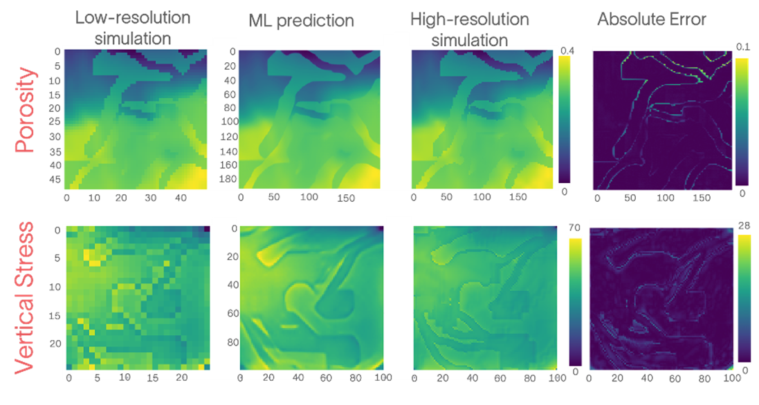
Figure 4. Comparison of the porosity and vertical stress 2D slices
Model usage in a resolution increase workflow
We tested our workflow based on the trained machine-learning model on real 3D simulated data from offshore Australia. We reported a significant decrease in computational time when property resolution for basin models was increased. We increased the resolution of the simulated porosity cube from the cell size 800 x 800 m to the cell size 200 x 200 m using both forward basin simulation on a high-resolution grid and our machine-learning model. A full pressure-temperature high-resolution simulation for a 3D cube with 1.5 million cells and 20 CPU cores took 3 hours and 30 minutes. Meanwhile, the resolution increase with our machine-learning model took 6 minutes only with a single CPU. This increases computational efficiency by more than 35 times with the current CNN architecture (Figures 5 and 6). This number can be even higher with the latest deep-learning architectures.
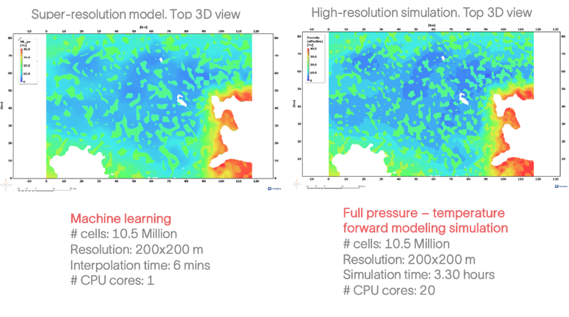
Figure 5. A comparison of using traditional simulation increase (right) and super-resolution model (left).
Basin modelers and exploration geologists can use super-resolution models in different ways. For example:
- To approximate the static properties of the subsurface rocks on the present day for regional sedimentary basins where the detailed fine-scale simulation would take days or be computationally difficult.
- To predict static properties of the subsurface rocks at every step of the geological evolution; e.g., if exploration geologists want to assess a high-resolution capillary pressure or stress map during fluid migration or trap preservation, which occurred millions of years ago.
- If a basin modeler or exploration geologist wants to preserve powerful physics-guided simulations in Petromod software but still wants to significantly decrease computation time, they may choose to use machine-learning super-resolution for specific geologic steps in basin simulation, as shown in Figure 7. This option enables the user to use machine-learning-based property resolution increase only for geologic events that are not important in terms of resource exploration; e.g., at the early stage of the evolution of the sedimentary basin or an additional simulation step inside a long-lasting geological event.
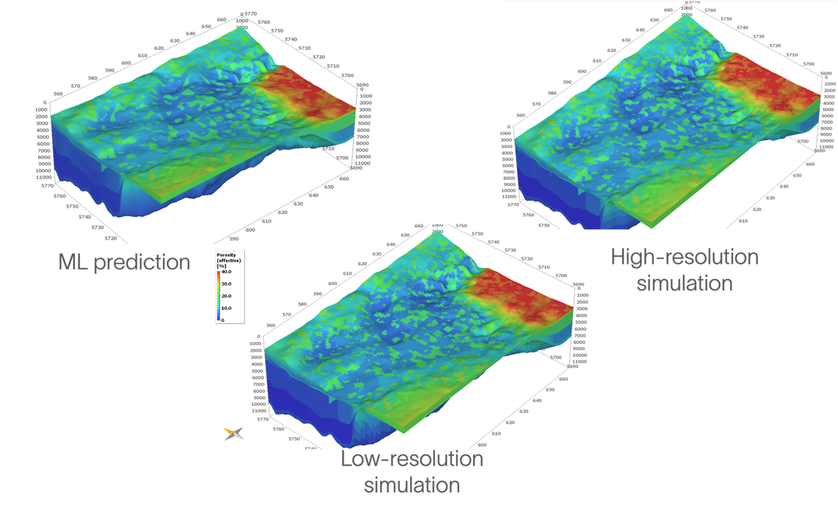
Figure 6. Demonstration of the porosity cubes from low-resolution, high-resolution, and a machine-learning prediction from the low-resolution simulation.

Figure 7. Schematic representation of using the ML super-resolution approach only for specific geological events during 3D basin modeling simulation through geologic time.
Conclusion
In this work, we demonstrated how we used a machine-learning super-resolution approach to increase the resolution of the subsurface property during forward simulations of sedimentary basins. Generally, this tool is a very convenient instrument for quickly generating high-resolution subsurface property scenarios. There are some advantages of this tool:
- order of magnitude faster than full basin modeling simulation
- results comparable to high-resolution simulation
- works in the Petromod graphical user interface
- outputs a 3D cube
Our solution represents a significant advancement in the field, as it effectively addresses the computational challenges associated with high-resolution subsurface modeling without compromising geological accuracy. It is important to note that this achievement is a result of our meticulous dataset curation, deep understanding of the subsurface basin modeling domain, and expertise in machine-learning model design and training. While our model provides a valuable tool for generating high-resolution scenarios, it should be used in conjunction with physics-based forward modeling to ensure comprehensive geological analysis.